Devil's Bedstead West - 11051 Feet
Location: 43.79021°N, 114.17904°W
Stats
Date: 8/12/2007
Distance: 13 miles
Elevation gain: 4200'
Class (difficulty): 3
Time: 7 hours
Range: Pioneer
Partner(s): Carrie D.
Report:
Having climbed more and more peaks in Idaho, I always think I am out of peaks in certain areas. So when a friend from work wanted to go climb a peak near Sun Valley that I hadn't done, I really struggled to think of something. As I cruised through Tom's book, Devils Bedstead West stood out for some reason. So I decided that would be a fun trip, with moderate mileage and elevation gain.
As me and Carrie (my friend from work) drove toward Sun Valley, we noticed a lot of smoke on the Camas Prairie. I didn't know it, but a fire in the Chimney Creek area has broken out the day before. This was kind of upsetting because the smoke from the fire appeared to be drifting right towards the Pioneer range. As we neared Trail Creek Summit (the start of the climb), the smoke was present, but not so thick. Views to the north were mostly clear.
I had been on the Summit Creek before when I climbed Phi Kappa and Summit Creek peaks several years ago. This time, I would follow the trail to its end at a scenic saddle overlooking Devils Bedstead West and the Kane Creek drainage. This is the point where Tom Lopez's webpage helped me out... according the web page, the trail continued down to the basin below and intersected a trail coming out of Kane Creek and this new trail would take us to the 10000-foot saddle just west of Devils Bedstead West. Sure enough, the trail continued toward the basin. When it petered out, we followed rock cairns to the trail coming out of Kane Creek (which can clearly be seen cutting across the rocky slopes of Peak 10360+). The trail heading to the saddle was in great shape and got us quickly to the saddle. At the saddle, the wind was roaring, but I was encouraged that we only had 1000 feet to go and the route was obvious.
As we headed up, we were both amazed that the rock was so solid. Within about 400 feet of the top, the rocks were larger, but still very stable with goat paths that could be followed. About 100 feet from the top, we were met with a narrow ridge to cross. The rock is very good here, but if you look close, the exposure on the east side of the ridge is several thousand feet. This section gave a sporting end to a very clean scramble.
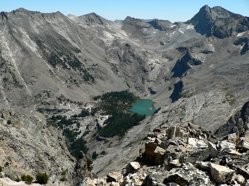
I guess I skipped the views on describing how I got to the top. Well, the views on the Summit Creek portion of the hike are nice. There are beaver ponds and meadows making that nice. The views from the west ridge of DBW are spectacular, with the east summit of DBW and DBE dominating the views on one side, with Goat Mountain and the gnarly ridge leading up to it dominating the other side. Once on top, you can look down at the emerald colored Kane Lake shimmering below Goat Peak. Of course, Castle Peak was visible to the north, as was Mystery Peak, which is one of those peaks that is going to be added to my "to do" list because it is so visible from so many summits in the Boulders and Pioneers.
All-in-all, it was a nice day to be in the mountains and smoke didn't turn out to be a factor. Carrie hiked at a comparable pace and turned out to be a good partner (we had hiked together before, but not alone). I highly recommend this peak!
Getting there:
From Ketchum/Sun Valley, follow Trail Creek Road to the summit. Look for the trailhead on the right hand side of the road.
Hiking instructions:
Follow the Summit Creek trail from Trail Creek Summit southeast for about 4.5 miles. Eventually the trail drops down into the Kane Creek drainage. The trail dies out, but you can spot a trail in great condition about 200 feet above the drainage that sidehills to the 10000' saddle just west of DBW.
Additional Info:
|
|
|