Hole in the Mountain Peak - 11306 Feet
Location: 40.95084°N, 115.1214°W
Stats
Date: 9/1/2007
Distance: 7 miles
Elevation gain: 4000'
Class (difficulty): 3
Time: 8 hours
Range: Humbolt
Partner(s): Zach
Our Route:

Report:
With several areas in central Idaho on fire, Zach and I chose to head south to escape smoky skies. We looked at county highpoints and prominent peaks and landed on Hole in the Mountain Peak near Wells. We had limited information about the peak, but pieced together what we could find and hit the area armed with a Topozone map.
We arrived in Wells late on a Friday evening. After a brief stop at Burger King, we headed for the trailhead in dwindling light. We knew from one trip report that the road was rough starting once we drove into Forest Service land. Sure enough, it became rough and steep at the point. From the start of Forest Service land, the hike would have been around 8 miles and 4500’, but we knew we could knock off some gain by just driving up the road a bit… plus we had to find a decent camping spot.
About 1 mile and 500’ in, we found a flat area after a very steep section of road. The spot had excellent views of the peak and the valley to the east.
After a bad nights sleep on slanted ground, we go moving around 7am. We realized immediately that we made the correct choice to stop driving where we did, as the road was steep, narrow, full of loose rock, with several large rocks mixed in.
We followed the road above Lizzie’s Basin to around 8500’ to a point where several vehicles were parked and hunters were camped out. Here (at the end of the road) we found a faint trail through the chaparral and followed it up a wide ridge to the base of a small cliff on the south side of the basin. We then followed the trail as it angled down along the cliff into the basin below, eventually crossing the stream below. After crossing the stream we headed for an obvious narrow chute on the right-hand side of the basin.
The chute started out at a low angle and seemed to only get steep in a few locations (seemed being the keyword… check back on this later). We headed up the chute for what seemed like hours, as it went from vegetated to alpine in nature. Just after we passed under the watchtowers that guarded either side of the chute, we finally reached the east ridge of the peak at 10300’. The views from here were tremendous, but we both knew we had some work left on what seemed like bouldery, but reasonable terrain.
We headed up the broad slope on stable boulders. Eventually the ridge narrowed and I hollered down to Zach that we only had about 100’ to go. Make sure you peak at the left side of the ridge here, as you see the near vertical face on that side, but follow ledges on the right hand side of the ridge for safer going. Once off the ledges and out of the boulders, you will arrive on gentle terrain that can be followed briefly to the summit.
The summit has a cairn with a register and wonderful views, especially of the dramatic dropoffs to the basin below. From the summit we spotted a mountain goat on a ledge of an incredibly steep slope. We also perused the summit log, realizing this peak is only climbed by about 5 people per year.
We had read on how there was an easy route to go visit the hole in the peak, so we headed south from the summit to find the gully to descend to get us around the cliffy terrain up higher and get us over to the window. We both looked down the gully and were shocked that it went down so far and looked so steep. We decided maybe a visit of the hole wasn’t so important. In one last attempt to find an easy route, we walked further south to find huge cliffs and dropoffs in all directions. While impressed, we decided the peak was enough and headed down.
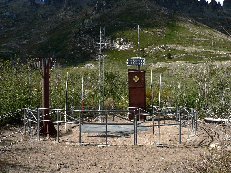
Speaking of heading down… we thought the chute was not-so-steep on the way up, but on the way down it was a pain. When we reached the vegetation and I nearly slipped on a few grass hidden rocks, I had had enough and decided to bail out of the gully (opting for the slope on the right side of the gully) and spare myself the last 1000’ in the gully. This choice paid off, as the slope I descended had good footing and I motored down it (though it looked sketchy at best when I looked back up it from below). This route did so well, that when got in the basin, I could see Zach was still 700 or 800 feet above me in the gully. After a nice nap, Zach caught up and we finished the descent, this time hanging very near the pond in the basin and checking out the snotel equipment nearby before rejoining the road.
Getting there:
Drive south on US 93 from Wells, Nevada for 5.25 miles. Take a right on signed state road 232 West. This road heads west for about 2 miles and then takes a turn south. At just over 8.5 miles from when you turned onto 232 you will reach a dirt road signed "USFS Weeks Access". Take a right and head west on this road. Drive 2.8 miles on this road, where you will reach a USFS sign and a cattle guard. The entire first 2.8 miles is all on private property and driveable by car. Once on USFS land (elevation: 6800 feet), the road becomes rocky and very steep. From here on up, if you're looking to drive you will need high clearance and 4WD. We stopped around 7300' at a flat spot just before a steep and loose section of road.
Hiking instructions:
We followed the road to its end at a point above and south of Lizzie's Basin. A faint trail headed west up through chapparal on a wide slope in front of us. We followed this trail for about 200 vertical feet to the base of a small cliff. From here, we followed the trail as it angled across the base of the cliff and dropped into the basin, eventually ending at the creek.
Cross the creek and ascend via a narrow gully on the southeast side of the peak (other routes looked feasible as well). From the end of the gully, follow the east ridge to the summit.
Additional Info:
Hole in the Mountain Peak is #10 on the Nevada prominence list, with 4849' of prominence.
|
|
|