Mica Peak - 5241'
Stats:
Date: 7/13/2008
Distance: 12 miles
Elevation gain: 2000' (cumulative)
Class (difficulty): 1
Time: 2:45
Range: Columbia
Partner(s): None
Report:
I was in the Coeur d'Alene are for the state softball tournament (we stayed in Liberty Lake, Washington to be exact). As usual, I sought out a peak to bag should I get some spare time. So in my search around the Coeur d'Alene area, I found a peak named Mica Peak that kind of stood out. Then I noticed it was close to our hotel (about a 15 minute drive to the trailhead). Then I found out it was one of the 50 most prominent peaks in Idaho. Now I was excited about the peak, but I still had to find some time to pull it off. Days 1 and 2 of the tournament were too busy. We won all of our games, so Sunday we were scheduled to play at noon. I spoke to the wife, and although as hassle, she agreed that I could try to climb Mica Peak after the game.
On Sunday morning, I woke up at 5:30am. I knew with the championship game that day that I had too much to think about and wouldn't go back to sleep. We had to leave for the fields by 10am, so I thought 4.5 hours would be long enough to do Mica. I got my gear packed and left the hotel. I drove following Mapquest directions to the top of the peak (I figured I would pull off the road and hike the last few miles). Instead, the road was gated about 6 miles from the summit. It was 6:15am and I did math calculations that told me I would have to be very quick to the top of the peak and probably have to run the way down to make it. So I headed out with nothing more than a 16oz water bottle, a 20oz Mountain Dew, and my camera.
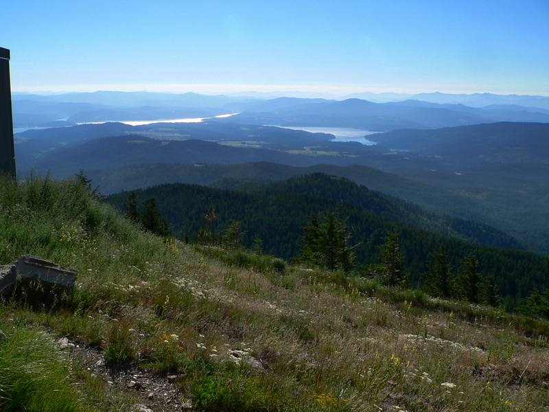
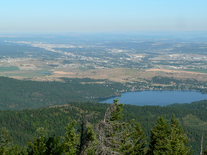
The road was fairly level and in the trees. I made good time. At 7am I left a small marker on the road so I could remember that spot and know I was 45 minutes from the trailhead on return. At 7:30am, I spotted a sign that pointed to the now visible lookout tower and communication equipment on the summit. I figured I needed to summit by 8am to give myself any chance of getting to the trailhead by 9am (so I could drive back to the hotel, shower, then get to warmups on time). The road really steepened at this point, but I kept pushing and summited at 7:58am. The summit views of Spokane, Liberty Lake, and the surrounding mountains were incredible. I downed the water, took about 10 pictures, and then headed down right at 8am. I wish I could have enjoyed the views more, but I was greatful enough to be out and on schedule. Getting back by 9am and having a 6 mile hike ahead of me meant I had to run 10-minute miles with a backpack and hiking boots to get back on time. I didn't really have a choice, so off I went.
My first gamble was to take a steep looking single track trail that cut the switchbacks in the road. Normally I wouldn't do this, but I was in a hurry and it was a heavily beaten path. The path was fast, but it was steep, loose, and my hurrying put me in danger a few times… but it got me to the lookout turnoff sign in 6 minutes (24 minutes less than it took me to get up). I then ran the road with short walking breaks, getting to my marker at 8:33am. I then ran most of the final section, getting to the trailhead at 9:02am and to the hotel at 9:20am (despite having to stop for a bike race). We went on to win the state championship that day. Some of the team ended up at the Coeur d'Alene beach that day and I pointed out the peak from the beach. Nobody seemed to get why someone would get up at 5:30am and do a 12-mile hike… and here I was thinking it was the perfect start to the perfect day!
Getting There:
Take I-90 to the Spokane Street exit (Exit 299). Go south on Spokane street across the bridge. Spokane street will turn into West Riverveiw Drive. Follow West Riverview for about 3 miles until you see a white fence on your left. Signal Point road is right near there. Take signal point road to the gate. They are very concerned about you staying away from the gate, so park below it the gate. I parked on the side of the road just before a switchback (the gate is immediately after the switchback).
Hiking Instructions:
Follow the road to the summit. There are several side roads, but always stick to the main road, which does exactly as shown on the topo.
|
|
|